


Hike the Mountain in the Sea
Words : Fiona Mcintosh. Photos: Shaen Adey. Article from the March 2015 issue of Country Life Magazine.
Fiona Mcintosh maps out her own multi-day route on the Hoerikwaggo Trail over Table Mountain.
 A hike from Cape Point to Cape Town must rank among the world’s iconic multi-day trails, like New Zealand’s Milford Track and Patagonia’s Torres del Paine Circuit. Sadly, SANPark’s attempt to establish the Hoerikwaggo Trail in Table Mountain National Park contracted typical big-project disease, with most of the trail and plush accommodation built before it was realised there was a problem with access for the short stretch from Smitswinkel to Redhill. Recently, a second access issue resulted in the closure of the section of the trail up the southern slopes of Chapman’s Peak, thereby severing the link between the Slangkop and Silvermine overnight camps.
While these disruptions to the planned ‘thru-route’ are frustrating, they shouldn’t distract the keen hiker from the fact that, as a result of the project, there are some 75km of well-marked, well-maintained trail and four splendid tented camps available for use along the Cape Peninsula. Throw into the equation one of the world’s most scenic coastal railways (from Cape Town to Simon’s Town) and some well- located, characterful coastal settlements (particularly Simon’s Town, Kalk Bay and Kommetjie) and, with a bit of imagination and planning, you can design your own Cape Peninsula hike.
I’ve completed one- to four-night variants several ways: backpacking, slackpacking and – a nice compromise – carrying minimal food and, where possible, eating in local pubs and cafes along the way. Each hike has provided such a different experience, but if you have three days and want to explore the Peninsula while staying in the tented camps, one of the best options is to catch the train from Cape Town to Kalk Bay and hike back from there. That’s exactly what some friends and I did a few months ago.
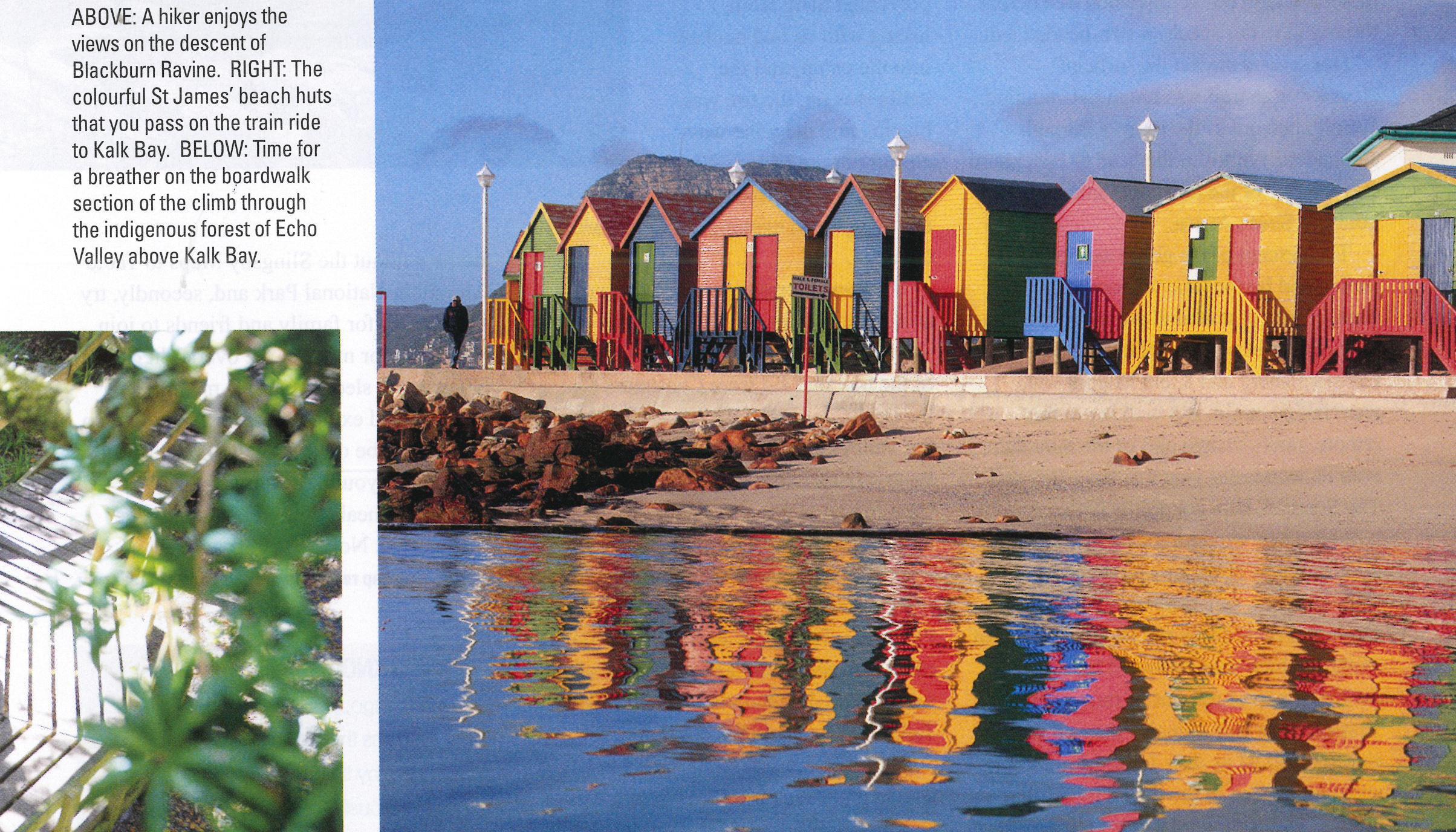
 Enamoured by the city’s much improved public transport system, we caught a MyCiti bus to Cape Town station and then a train to Kalk Bay. It was a delightful trip. From Muizenberg we gazed out of the window enjoying the spectacular views over False Bay, the seaside resort’s art deco buildings and the colourful beach houses of St James before the train chugged into trendy Kalk Bay where we alighted and sought out a coffee shop.
Energised by our caffeine fix, we hiked up to Boyes Drive where we picked up the Ou Kraal path that led up through the magnificent indigenous forest to the towering cliffs of Echo Valley and the Kalk Bay Amphitheatre, the perfect spot for a tea break. After climbing out of this natural bowl we sauntered down through the dense stands of leucadendrons that clothe the Steenberg Plateau, to Silvermine Gate 2 (the Wolfkop entrance gate to Silvermine East) and across Ou Kaapse Weg to the Silvermine Reserve’s main entrance – some 500m along the tar road.

From here we picked up the shady River Walk, a glorious hike, much of it on boardwalk alongside a tinkling stream that took us past big stands of palmiet reeds, exquisite ericas and pretty pink keurboom trees in bloom, all the way up to the Silvermine Tented Camp.

The lovely two-person cabins at Orange Kloof.
Like all the Hoerikwaggo camps, this gorgeous overnight spot near the wind-sculpted Silvermine crags is built from alien vegetation and is ingeniously designed to reflect the surrounding environment. In deference to Silvermine’s popularity as a rock-climbing area, the walls of the communal lounge/kitchen are a mini-climbing wall. There’s a fully equipped kitchen but we opted to braai under a stately old yellowwood tree before turning in to our spacious two-bedded tent.

The Upper Cableway station on Table Mountain with Lion’s Head in the background and the scenery on the final descent to Slangkop tented camp.
Our second day on the ‘official’ Hoerikwaggo trail was tough but stunning. We climbed out of the reserve through stupendous fynbos to the head of Blackburn Ravine, one of the most dramatic lookout points in South Africa.
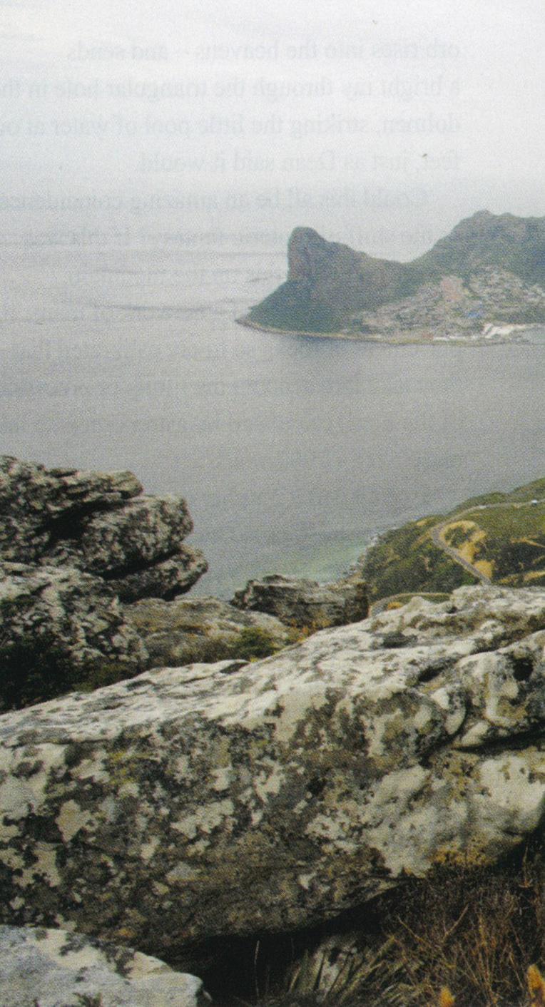
The descent of the gorge was knee- jarring and by the time we reached the contour path that wound around to the start of the next climb – the nek between Constantiaberg and Klein Koppie – we were taking strain. But walking in this remote, rarely visited part of the mountain, with its wonderful views of Hout Bay and The Sentinel, kept our spirits high.
Just when we thought the worst of the climbing was over, we spied yet another steep descent, this time on a rough, vegetated path down the Bokkemanskloof stream, which was followed by another steep climb out of the valley to Vlakkenberg Nek. Finally the end was in sight; ahead of us was Table Mountain and somewhere in the dense forest that clothed its lower flanks was Orange Kloof Tented Camp.
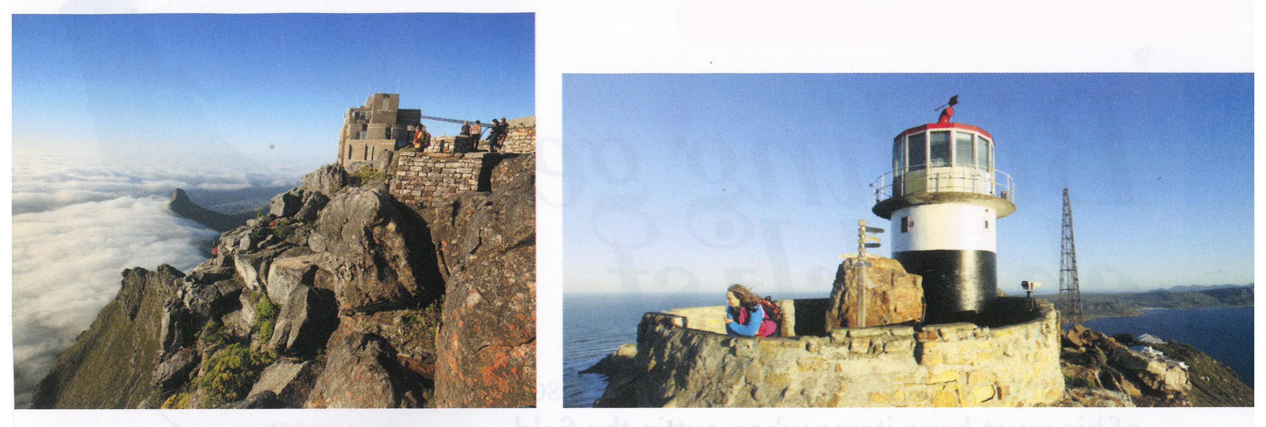
Factor in some extra time to explore the Cape Point lighthouses if you’re hiking the section of trail through Cape of Good Hope Reserve.
We arrived at camp weary after nearly eight hours on the trail. But we were organised. Friends whose work commitments prevented them from hiking with us had booked into the camp, and the kettle was on, the fire was blazing and the wine was chilling in the fridge. What a pleasure, after freshening up, to enjoy an evening cooking under the stars.
 The next morning we bade farewell as our mates departed for work, and shouldered our packs for the final section of the trail that led from Constantia Nek up the Bridle Path, past the reservoirs, through the Valley of the Red Gods and up the final steep section to the Upper Cable Station. Like any good trail the Hoerikwaggo trail had saved the best until last; this was a glorious hike through magnificent fynbos with 360° vistas of the city and the Peninsula. Taking the easy way down in the cable car seemed an inappropriate end and we chose to descend via Platteklip Gorge to Tafelberg Road and the bus home.
Devising our own route was fun but, if you’re planning on following suit, I have two pieces of advice. Firstly, don’t leave home without the Slingsby Maps to Table Mountain National Park and, secondly, try to organise for family and friends to join you at one or more of the overnight camps. They get to sleep out in the magnificent location and explore parts of the mountain that they’d be otherwise unlikely to visit, and you, if you play your cards right, have your meals cooked and your bags transported. Not a bad trade-off.
Did you know?
Hoerikwaggo, meaning ‘mountain in the sea’ was the name given to Table Mountain by the indigenous Khoi people who previously inhabited the Cape.
Don’t forget Peter Slingsby’s excellent, extremely detailed set of maps of Table Mountain National Park show the route of the Hoerikwaggo Trail and the other trails on Table Mountain and the Peninsula.
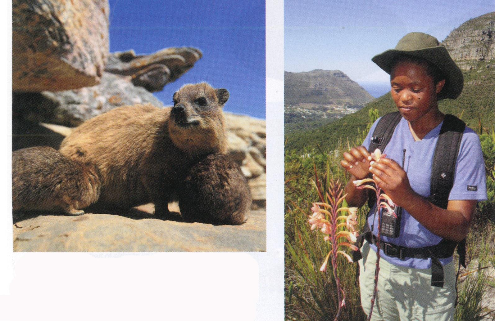
Dassies are often seen catching the sun on the rocks. RIGHT: Taking an accredited guide enhances the experience as you learn about the unique fauna and flora of the Cape Floral Region as you walk.
In a Nutshell
Up to it? You need to be fit but there are shorter, less demanding options, such as the section through the Cape of Good Hope Reserve and the hike from Redhill Road to SlangkopTented Camp. www.sanparks.org/parks/table_mountain/ht/ How to do it Slackpacking on a guided, fully catered trail is the way to enjoy Hoerikwaggo. There’s no organisational schlep and you learn about the unique flora and fauna, and it’s safer as the route covers some remote locations. A section of trail (Orange Kloof up Disa Gorge ontoTable Mountain) is also only accessible to guided groups. The booking office has accredited guides and operators offering bag-transfer services. Reservations 021 712 7471, website.
![]()
![]()
![]()
![]()
Related Articles


Book your accommodation right here on ShowMe.
You can find the top hotels, lodges and Airbnb establishments conveniently placed on the map below. All you need to do is click on the place that’s conveniently located and within your budget and then make a booking. What could be easier?
If the map is not where you want to be, click on the ShowMe Pin and then enter the exact name of the location and the map will adjust accordingly.
