


San, sand and sundry animals, West Coast mountain bike trail
Words and photos: Carlo Jonkerman. Article from Ride Magazine October 2015.
The Cape West Coast is better known for fishing villages, unspoiled beauty and its hospitable people, but the mountain-bike trail at !Khwa ttu San Culture and Education Centre is well worth a visit too.

Just 70km out of Cape Town, at the gateway to the West Coast between Darling and Yzerfontein, you’ll find !Khwa ttu San Culture and Education Centre. Originally opened to the public in March 2006, !Khwa ttu – which means watering hole in the language of the !Xam – aims to keep the history of the San people alive, and accessible.
The San are deemed to be the first indigenous people of Southern Africa, and it is their descendants who twice a day guide walks through the 850ha reserve, at the ready to tell you all about their history, culture, languages and modem-day life.
As a bonus for us cyclists, they also opened up unguided mountain-bike trails in November last year. The Green route takes in only the !Khwa ttu village (think sand, rock faces, springbok, eland, oryx and zebra), while the Red route (and Black loop) extends onto neighbouring farms (wheatfields, cows, sheep, vineyards and olives).
If you head there on a weekday, you may even have the good fortune to encounter all of that without seeing another human. Bliss!
 Go Green
Distance: 10km
Time: 45min-1 hour
Difficulty: Intermediate
The 10km-long Green route forms part of the longer Red route, which splits off after about two-thirds of the way, eventually to rejoin there and finish as the Green does.
The information boards at the start of the two routes (to the right of the main reception and accessible on the road around the parking lot) says the Green Route is half singletrack, half jeep track. You’re also warned to expect game on the route, and you won’t be disappointed, so keep your head up as a herd of springbok may be practising their big hits around the next corner.
As you head through the start point, it’s a nice, flowing freewheel down to Bridge 1 on the trails – the first of 11 on the two routes. Shortly thereafter, at a junction where the walking trail splits from the mountain-bike trail, keep right past the bird hide.
As you begin the stepped and switchback off-camber climbing, get used to seeing motivational signs like ‘Life Behind Bars’. They’re posted all over the trails – often at points where tired legs might want to pack it in!
You don’t climb for too long before you get to the far end of the property alongside the road to Darling. Here starts a gentle descent around to the back of the property, where the neighbouring farms come into view.
Just as you’re lulled into thinking that you’re doing a big loop, the switchback climbing starts. The surface is firm but the path is a bit-off camber, so maintain your speed to avoid slipping and sliding. At the top of the bends you’ll reach an attitude of 230m, ostensibly the highest point and halfway mark of the Green route.
On the way down, you’ll encounter the first section of a technical descent (a rock face), but it’s not as technical as the one alongside the boma around the corner.
Where to graze
Whether you’ve arrived early enough for breakfast, or are looking for a post-ride chow or even a quick coffee (and piece of cake), the on-site restaurant (open 9am-3.30pm) will deliver.
It is housed inside the original farmhouse, which has been restored over the past five years to seat 60 people.
If the sun is out, head straight for the patio outside to enjoy views of the West Coast. As with all the activities at !Khwa ttu, your food will be prepared and served by San people.
If you’re with the family on a leisurely ride, definitely stop at the boma to get an elevated view of the land and game below and the West Coast in the distance. There’s even a pit stop in the vicinity if you’ve downed too much water up to that point.
If it’s a rainy day or you’re a beginner, we advise that you continue your ride on the chicken run (clearly signposted and marked in yellow) around the front of the boma, away from the rock-faced descent.
if you’re confident in your technical descending skills then take it on, but be aware that the surface is loose gravel at the bottom of the rock face, so be careful as you enter the singletrack and round the watering hole down to the farm road ahead.
You’ve now completed two-thirds of the Green route, and a 500m farm-road journey takes you roughly in the direction of the start point for the last third. It’s at this point that serious riders head off to the left for the proper Red route, while the Green route goes straight ahead.
You’re now met with a meandering climb to the top of the second koppie on iKhwa ttu land. Around the back of it, the switchback descent is quite tight and be aware that there could be game there too… don’t get a skrik or you’ll end up in the fynbos. If you haven’t, you’ll now have a gentle rolling descent to the finish line.
 Red Alert
Distance: 30km TIME: 2-3 hours
Difficulty: Intermediate
Soon after the Red route splits, Bridge 2 has to be crossed onto Grootberg farm, which basically begins the transitional phase of the longer route.
Here you freewheel down a sandy jeep track to the third bridge, turn right onto the farm road headed for Bridge 4 and then Bridge 5, and cross onto Ormonde farm where the real riding starts.
A fairly rutted farm road climb gets your heart rate going, but it undulates, so you don’t have to go full-out. In turn, don’t get lulled into a false sense of security atop it, because around the corner is another shorter burst before you can get a proper rest. Ours was forced, as the farm gate wouldn’t open no matter how hard we tried, so our ride was interrupted by a tricky pass-the-parcel episode over the barbed-wire fence.
A bit of respite on some jeep track takes you to and over Bridge 6, before your next bit of climbing to Bridge 7 – again it’s not particularly long or steep, taking you to an altitude of only 280m. As a bonus, next up is some freewheeling down to Bridge 8, although not on the best-kept singletrack of the trails. Expect a few dongas, dips and off-camber riding.
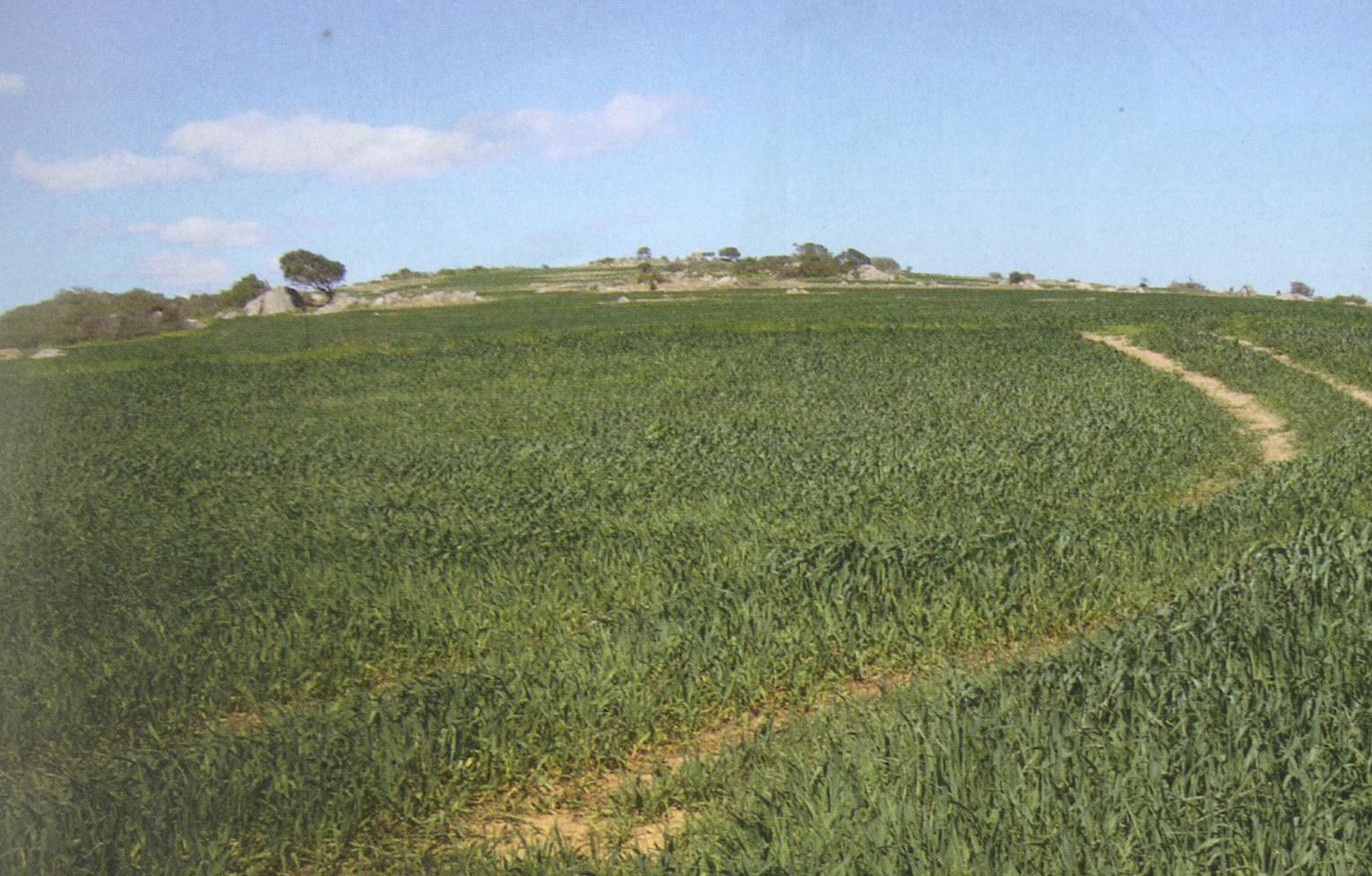
Bridge 9 comes up next, taking you to a stretch around Ormonde’s vineyards which is not the most exhilarating part of the route – completely the opposite, in fact. It’s one thing riding on a slightly off-camber clayey surface, but another watching your tyres fill up with duiweltjie thorns… while having only row after row of vineyard for company.
In fairness, once September starts you’ll be more inclined to see the winemaking process in operation, as the vines are tended to from then, so that could be a better time to go if you’re riding on your own.
As the end of vineyards come clearly into view, at two water wells, so does a radio mast… luckily, if you’re not in the mood for more climbing, the mast is only part of the Black loop.
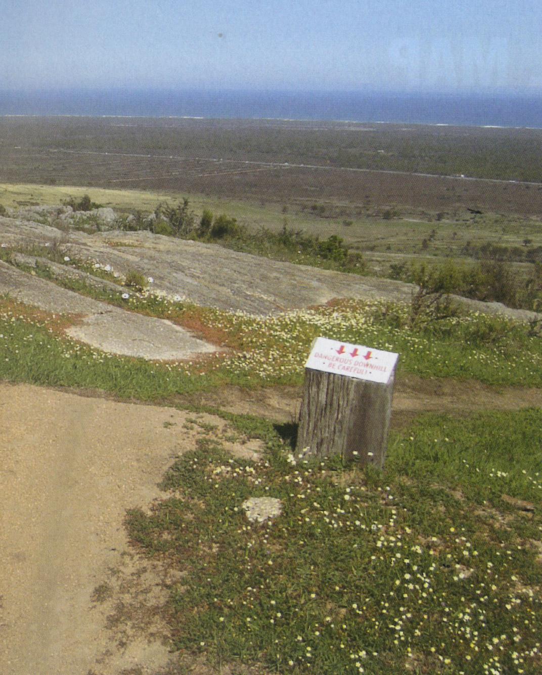
An early warning that the Black loop is on its way is the only bit of tar that you ride, but Bridge 10 comes up on the right just as the tar heads upwards. Take heed of the ‘Dangerous Downhill’ warning after the bridge – the sketchy road down is filled with rocks and dongas, and it’s off camber, so don’t let your momentum end your ride there.
Your last major obstacle is not far off: a short climb to Mina se Klip and a descent down its face. Then, if you’ve counted bridges religiously, you should get excited when you get to number 11, the last on the outward leg of the journey.
That said, around the corner your heart may start to sink looking at the sandy farm road heading upwards ahead of you – but then up pops a ‘sho’t left’ sign to save you. Then, after about 200m of riding, you should be struck by a feeling of ‘I rode this earlier’ and you’ll realise you’re now on the way home… Bridges 5, 4 (hello cows, hello sheep), 3, and 2 lie ahead, then the last third of the Green route and you’re home.
If it feels like you’ve done quite some climbing, console yourself with this fact – while the Red route is hilly, you’ll have climbed only 800m or so.
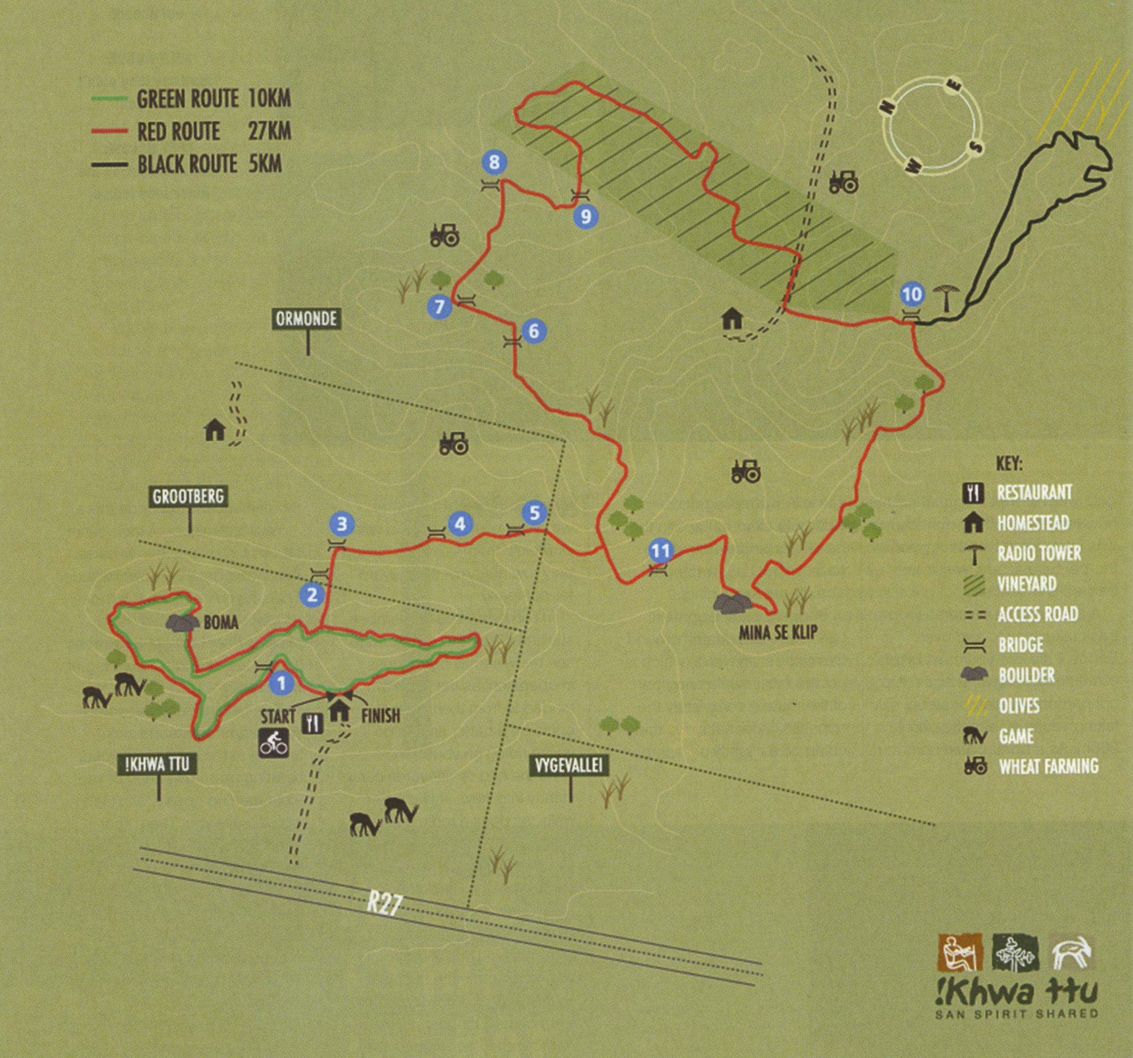 Trail map
Where to hit the hay
You can make a romantic or riding club weekend of it at !Khwa ttu, with five accommodation options available that can host up to 39 people per night. Three of these are on the sea side of the R27.
The Bush Camp consists of five two-person tents (each person gets a single bed); the Bush Village has 10 tents (which are also two-person but have mattresses), while the more secluded Bush House sleeps four, in two bedrooms. At the main iiKhwa ttu site, there are two guest houses that sleep two and three respectively. Alternatively, if you want to stay at the seaside, try Yzerfontein, or if you prefer to be inland, there’s darling – both are about 15 minutes drive from !khwatu ttu.
You’ll now snake your way up through the field to the beacon
 Black Ops
Distance: 5km TIME: 20-40min
Difficulty: Intermediate to difficult
Remember that tar road up to a radio tower you didn’t have to do on the Red route?
Well, now you’ll have to ride up it, and continue on to add the Black loop for the full 35km available at !Khwa ttu.
Once you get to the radio tower, you won’t immediately see what the rest of the loop will entail, but that beacon on the koppie across a dip should give you a pretty good hint. In other words, if your legs are pap, rather bank the climb to the tower and head back down to the Red route.
If you’re still feeling strong (bearing in mind you’re about 10km from home), continue through the gate alongside the tower where the loop becomes even more clear; a farm road rises up to meet you, but another black arrow points left towards the fence. We promise there is a rideable path there, but it’s initially a bit of bundu-bashing as the singletrack heads down rapidly alongside the fence.
When you exit the singletrack, head along the jeep track for about 100m until the water well, where you’ll turn right – hopefully the black arrow will be nailed back on the pole by the time you go, so you don’t miss it!
You’ll now snake your way up the path through the field and to that beacon you saw from the radio tower – the 360-degree vistas of the Swartland are worth the climb.
Sip some water before speeding back down to the water well, because the climb back to the radio mast finishes off the Black loop. It’s not a steep ascent, but it’s off-camber in some parts and sandy in others, and crosswinds can be a factor.


Related Articles


Book your accommodation right here on ShowMe.
You can find the top hotels, lodges and Airbnb establishments conveniently placed on the map below. All you need to do is click on the place that’s conveniently located and within your budget and then make a booking. What could be easier?
If the map is not where you want to be, click on the ShowMe Pin and then enter the exact name of the location and the map will adjust accordingly.
